Glaciers flattened, eroded and shaped the region.
Shaped the land around us. The layer between the limestone and the topsoil.

The Pleistocene epoch, which lasted from about 2.6 million years ago to around 11,700 years ago, was a time of significant geological and ecological change in the Western Ohio area. During this period, the area was covered by ice sheets and glaciers, which shaped the landscape and influenced the flora and fauna that lived there.
Geologically, the Pleistocene was characterized by the advance and retreat of glaciers, which repeatedly covered and uncovered the western region of Ohio. As a result, the area is marked by a series of glacial deposits, including glacial till, moraines, and outwash plains. These deposits have a significant impact on the landscape and are still visible today.
South Western Ohio's terrain was shaped by the Pleistocene Glaciers, flattening and eroding the landscape and creating the planes and valleys we see today. Several Glaciations over time impacted Clermont County and the surrounding areas. These Glaciations are the Pre-Illinoin, The Illinoian, and the Wisconsinan Glaciations.
The two glaciations that affected Clermont County were the Pre-Illinoian and the Illinoian The later Wisconsinan stopped to the North and West of the County but the water continued to cut and erode the Valleys through out the County.

This LiDAR DEM of the State of Ohio shows the Glacial scaring and leveling of the Western and Central part of the State. Moraines are visible as wavey lines. The Central-Eastern and South-Eastern parts of the State were not Glaciated as seen with the topography.
Before the Glaciers the Ohio River did not exist and the water in our region flowed North into the Teays river system.
")
Roughly 2 million years ago, during the late Tertiary period, the Ohio River did not exist. Instead, the Teays River (pronounced "taze") dominated the landscape.
Origin: Its headwaters were in the Blue Ridge Mountains near Blowing Rock, North Carolina.
Path: It flowed north through Virginia and West Virginia (following what are now the New and Kanawha River valleys).
The Ohio Segment: The river entered Ohio near Wheelersburg, flowed northwest through Chillicothe, and then cut a deep path across western Ohio through Pickaway, Madison, and Mercer counties.
Final Destination: It crossed Indiana and Illinois (where it is known as the Mahomet Valley) before eventually emptying into an ancestral version of the Mississippi River.


The end of the Teays began with the Pre-Illinoian Glaciations (roughly 800,000 to 1 million years ago). As the massive Laurentide Ice Sheet pushed south into Ohio, it acted as a colossal dam, blocking the northward flow of the Teays near present-day Chillicothe.
The Formation of Lake Tight
With its northern exit blocked by ice, the Teays River backed up, flooding the deep valleys of southern Ohio, West Virginia, and Kentucky.
Scale: This created Lake Tight, a massive proglacial lake covering over 7,000 square miles—nearly the size of Lake Erie.
Legacy: The lake existed for thousands of years, depositing thick layers of fine-grained "Minford Silt" and clay.
These sediments still fill the ancient abandoned Teays valleys today, often found hundreds of feet below the surface in glaciated areas.
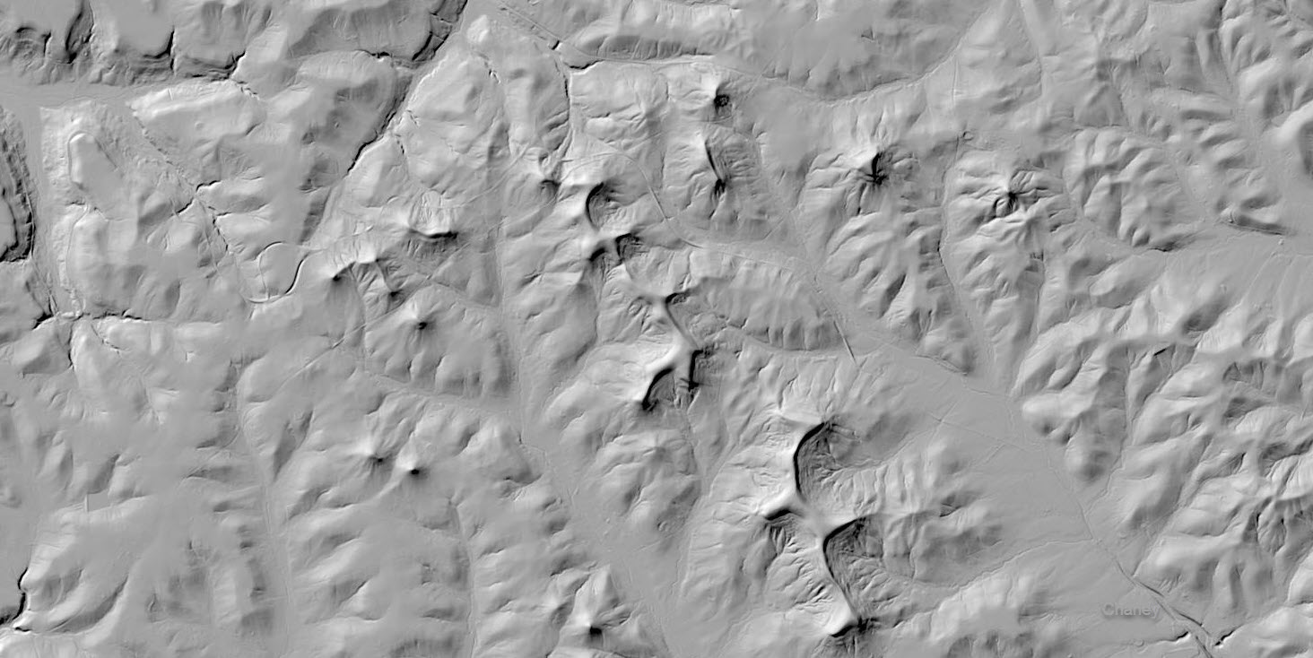
LiDAR DEM image of the modern boundary where the Glaciers, Teays river and Lake Tight were during the Pre-Illinoian and Illinoian Glaciations. This is the Chillicothe Ohio region. The areas to the North and West in the image have more water erosion from being flooded and part of a lake
The image below shows the Lake tight water erosion and the tips of Islands from long ago during the Illinoian Glaciations.

As Lake Tight grew, its waters eventually overtopped the surrounding hills (drainage divides). The most significant breach occurred at a high point (or "col") near Sardis, Ohio. This catastrophic overflow carved a new, southern-flowing channel that would eventually become the Ohio River.
The Deep Stage Phase
During the Pre-Illinoian and the subsequent Illinoian Glaciation, the volume of meltwater was so immense that it carved a trench into the bedrock far deeper than the modern riverbed.
Deep Stage Characteristics: This "Deep Stage Ohio" flowed in a narrow, gorge-like valley.
In some places, the bedrock floor of this ancient river is 100 to 150 feet below the current bottom of the Ohio River. The gravel quarries in the valleys dig out the sediment of the Deep Stage Ohio down to the bed rock base of the original river Redirection: The Illinoian glacier further redirected the river near Cincinnati, forcing it out of its northern loop (the "Old Licking" path) and into the straighter, narrower channel we see today between Kentucky and Indiana. This breach occurred at Anderson Ferry west of Cincinnati.

This LiDAR DEM of the State of Ohio shows the Glacial Moraines of the Wisconsinan Glaciation. The last Glaciation of the Ice age here in Ohio which did not enter Clermont County. The Water however did further eroding the valleys.


The Pleistocene Epoch in Ohio featured an incredible diversity of Ice Age megafauna, including iconic giants like woolly mammoths and American mastodons, and giant ground sloths, alongside unique creatures like giant beavers and short-faced bears, with evidence of these animals found throughout the state in various deposits, even alongside early human artifacts at the end of the Ice Age.
- Mammoths & Mastodons: Both Woolly Mammoths (Mammuthus primigenius) and American Mastodons (Mammut americanum) roamed Ohio, with mastodons being particularly common in fossils.
- Giant Ground Sloths: Species like Jefferson's Ground Sloth (Megalonyx jeffersonii) left their remains in Ohio.
- Giant Beavers: Castoroides ohioensis, the largest rodent in North America, was native to Ohio.
- Bears: The giant short-faced bear (Arctodus simus) was a significant predator.
- Bison: Ancient bison (Bison antiquus) lived in the region.
- Muskoxen: Both modern muskoxen (Ovibos moschatus) and extinct forms were present.
- Carnivores: Dire wolves, though less common in fossil records than herbivores, also existed in Ohio.
- Other Mammals: The region hosted saber toothed cats, peccaries (like the Flat-headed peccary), elk-moose, and various smaller mammals.
- The region was also home to various insects, amphibians, birds, fish, and reptiles, many of which are still present in the area today.

The flora of the Western Ohio area during the Pleistocene was influenced by the climate and geology of the region. During glacial periods, much of the area was covered by tundra and boreal forests, which supported a variety of cold-adapted plants such as grasses, sedges, and shrubs. As the climate warmed and the glaciers retreated, the area was colonized by deciduous trees such as oaks, hickories, and maples.
The climate in Clermont County during the Pleistocene was not always "frozen," but it was significantly cooler than today.
Periglacial Tundra: When the ice was at its peak, the local environment was likely a treeless tundra of mosses, lichens, and hardy grasses, characterized by permafrost (permanently frozen ground).
Boreal Forest (Taiga): As the glaciers retreated, the county was covered by a dense "Spruce-Pine" forest, similar to modern-day northern Canada or Alaska. Geologists have found fossilized spruce logs and needles buried in Clermont’s glacial till, proving these trees once stood where cornfields are now.
The "Bluegrass" Transition: The southern tip of the county, near the Ohio River, acted as a corridor for plants and animals moving between the ice-free Kentucky hills and the glaciated plains.
Overall, the Pleistocene epoch significantly impacted the geology, flora, and fauna of the Western Ohio area. Today, the region is marked by a complex and diverse geological history, and the flora and fauna of the area reflect a long history of adaptation and change in response to environmental pressures.